The Problem of Tectonic Plates in Indonesia
What is the problem?
The problem we are investigating relates to the impacts of plate tectonics on the country of Indonesia. Due to the movement of these plate tectonics which make up the Earth's crust, Indonesia is being heavily impacted with a large amount of natural disasters. Our website will look into the problems in Indonesia that have continually arisen from these plate tectonics, by both looking into the problem itself and the effects of it being there, both economically on the lives of people in Indonesia. A variety of maps and diagrams will be used to more clearly explain the location of the plates, as well as how these plates interact with each other to cause damage to the people of Indonesia. Many graphs and charts will also be used to show trends and to compare the economic impacts that these plate tectonics are having on Indonesia. More importantly however, we will evaluate several responses taken by both groups and governments around the world to counteract the problem, followed by our ideas on what could and can be done to potentially reduce the damage.
Background to the Problem
Indonesia is located 6 degrees 11 minutes South and 106 degrees 50 minutes East in terms of longitude and latitude (see Figure 1.1). It is an archipelago consisting of 17,000 islands, located in Southeast Asia, with the largest islands including Java, Sumatra and the Nusa Tengerra Islands. Indonesia is part of the "Ring of Fire" (Figure 1.2), which is a string of volcanoes and earthquakes, with 90% of all earthquakes occurring along there and also represents 75% of all active volcanoes on Earth. The high occurrence of natural disasters in this "Ring of Fire" is due to the fact that it is a region that is particularly active geologically, as it marks the boundaries between a number of plate tectonics. Since Indonesia lies between both the "Ring of Fire" and "Alpide Belt", which is a powerful mountain range extending along the mountains of Southeast Asia and the Himalayas, it means it is prone to both the strongest earthquakes and most powerful volcanoes.

Figure 1.1: This is a longitude and latitude map of Indonesia, which is indicated by the yellow areas. The country capital is Jakarta which is located 6 degrees 11 minutes South and 106 degrees 49 minutes east. Indonesia is surrounded by many bodies of water including the Indian Ocean, Banda Sea and the Malucca Sea. The international boundary is located between Malaysia and Singapore.
Source: http://www.mapsofworld.com/lat_long/indonesia-lat-long.html
Source: http://www.mapsofworld.com/lat_long/indonesia-lat-long.html
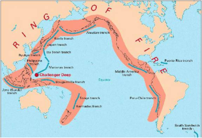
Figure 1.2: This is a map indicating the area covered by the Ring of Fire (indicated in red). As shown, almost the entirety of Indonsia (middle-left) is in this region, which suggests why the country experiences some of the most destructive natural disasters in the world. In the Ring of Fire there are many trenches which are formed as a result of subduction zones, where one tectonic plate dives below the other. On the Ring of Fire, we see that Challenger Deep, the deepest point in the hydrosphere's seabed, lies north-east of Indonesia.
Source: http://www.livescience.com/8823-indonesia-explosive-geology-explained.html
Source: http://www.livescience.com/8823-indonesia-explosive-geology-explained.html
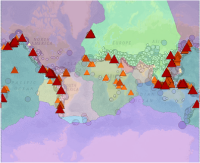
Figure 1.3: This thematic map shows the volcanic eruptions, surface elevation, earthquakes and plate tectonics in the world. Since Indonesia is located in the "Ring of Fire" you can see the cluster of volcanoes and earthquakes. The triangles represent the volcanoes, the circles represent the earthquakes and the different colours separate the tectonic boundaries. However, there may be a misconception to the amount of earthquakes which are situated in Indonesia as most of the volcanoes in the diagram are covering them up. The tectonic boundaries cannot be clearly seen showing the common occurrence of natural disasters in Indonesia as they have been covered by triangles representing the volcanoes and circles representing the earthquakes.
Source: http://mapmaker.education.nationalgeographic.com
Source: http://mapmaker.education.nationalgeographic.com

|
|
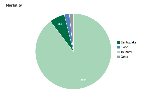
Figure 1.4: The table on the right shows the 8 year moving average during 2005-2013 of extensive and intensive natural disasters as a percentage. Extensive refers to disasters affecting a large while intensive refers to disasters covering a smaller area. It is ironic that most of the deaths from natural disasters are from smaller natural disasters, probably due to the high frequency in which they occur. Overall, we see that intensive disasters have a greater effect in almost every aspect. The pie chart on the right shows the causes for natural disasters, with a staggering 89.7% due to tsunamis, while the other natural disasters such as earthquakes and floods, although have a profound effect, are not as commonly occurring.
Source: http://www.preventionweb.net/countries/idn/data/
Source: http://www.preventionweb.net/countries/idn/data/
With the UN report estimating that over 18 million people in Indonesia were affected by natural catastrophes in 1980 to 2009, it is apparent that despite the initiatives being taken to address the vulnerabilities to natural disasters, results are still lacking. Despite Indonesia's strong development of its disaster management initiatives since the 2004 tsunami as well as the implementation of an 'Indonesian Tsunami Early Warning System', recent disasters show that further improvements are needed especially in those of early warning systems and disaster-risk awareness capacities.
Many local governments are unwilling to use their budgets for disaster management as it places heavy strain on resources at the national level, especially for those who are facing multiple disasters at the same time. The 2009 Global Assessment Report on Disaster Risk Reduction which shows human exposure to disasters, ranks Indonesia 3 out of 153 for earthquakes and 1 out of 265 countries for tsunamis.
