Impacts of Earthquakes/Tsunamis
Earthquakes are one of the largest threats from moving plate tectonics in Indonesia as they come sudden and can strike in densely populated areas, such as the bigger cities. Earthquakes with a magnitude of around five or six on the scale of Richter happen almost on a daily basis in Indonesia but usually cause no or little damage. When the magnitude becomes over seven on the Richter Scale however, an earthquake can potentially do a lot of damage. Yearly, two or three earthquakes with a magnitude of seven or higher occur in Indonesia and cause casualties and damage the infrastructure or environment.
Earthquakes are one of the largest threats from moving plate tectonics in Indonesia as they come sudden and can strike in densely populated areas, such as the bigger cities. Earthquakes with a magnitude of around five or six on the scale of Richter happen almost on a daily basis in Indonesia but usually cause no or little damage. When the magnitude becomes over seven on the Richter Scale however, an earthquake can potentially do a lot of damage. Yearly, two or three earthquakes with a magnitude of seven or higher occur in Indonesia and cause casualties and damage the infrastructure or environment.
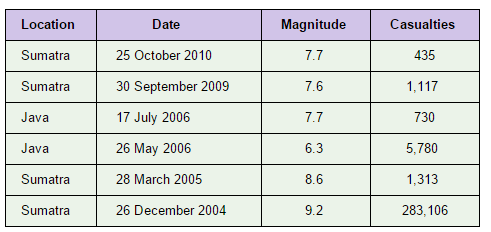
Figure 3.1: This is a table that shows the Location, Date, Magnitude and Number of Casualties that have resulted from recent earthquakes in Indonesia. There is a general trend for Sumatra and Java to be most heavily affected by earthquakes, at least in terms of lives lost, as suggested by the table. This is because both cities are located on the coast of Indonesia, meaning they are also potentially affected by underwater earthquakes that cause tsunamis. Furthermore, Sumatra have experienced the largest magnitude earthquakes with the 2004 earthquake registering at 9.3 on the Richter Scale and resulted in a staggering 283,106 casualties.
Source: http://www.indonesia-investments.com/business/risks/natural-disasters/item243
Source: http://www.indonesia-investments.com/business/risks/natural-disasters/item243
An earthquake that occurs underwater, in the oceans, almost always results in mass displacement of the water surrounding it. The height and destructive power of these waves depends on the magnitude of the earthquake that generated it. When the force of the waves created is strong enough, it is specifically identified as a tsunami. On average, it has been identified that a large tsunami (caused by an earthquake of magnitude 7+) reaches areas of Indonesia every five years, with most hitting the cities of Sumatra and Java. In general, evacuations are often made in time in tsunami prone areas, as many Indonesians living in coastal cities are able to flee to the hills located further inland to avoid loss of life after being notified of an offshore earthquake. However, the existing infrastructure and agriculture are unable to be saved, meaning tsunamis often devastate the Indonesian economy.
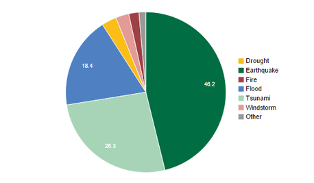
Figure 3.2: This is a pie chart that how each of the main disasters in Indonesia contributed to the combined economic loss in Indonesia from 1990-2014. The pie chart clearly shows the earthquakes and tsunamis make up the large majority at 72.5%, nearly 3/4 of all natural disasters in Indonesia.
Source: http://www.preventionweb.net/countries/idn/data/
Source: http://www.preventionweb.net/countries/idn/data/
Case Study: 2004 Indian Ocean Tsunami/Earthquake
Just over a decade ago, on the 26th of December 2004, the Indian Ocean tsunami would result from a giant underwater earthquake that occurred off the the coast of northern Sumatra, in Banda Aceh, a city in Indonesia, with its epicentre shown in the map below. This underwater earthquake was the result of a thrust fault that occurred in a subduction zone where the Australian plate was subducting under the European plate. As a result, the ocean floor broke, releasing its energy in a massive 9.1 magnitude earthquake, which subsequently caused large scale displacement of water in this region, ultimately generating massive tsunami waves which hit coastal communities surrounding the epicentre of the disaster, with the region of Aceh in Indonesia being hit the hardest in particular.
Just over a decade ago, on the 26th of December 2004, the Indian Ocean tsunami would result from a giant underwater earthquake that occurred off the the coast of northern Sumatra, in Banda Aceh, a city in Indonesia, with its epicentre shown in the map below. This underwater earthquake was the result of a thrust fault that occurred in a subduction zone where the Australian plate was subducting under the European plate. As a result, the ocean floor broke, releasing its energy in a massive 9.1 magnitude earthquake, which subsequently caused large scale displacement of water in this region, ultimately generating massive tsunami waves which hit coastal communities surrounding the epicentre of the disaster, with the region of Aceh in Indonesia being hit the hardest in particular.
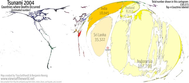
Figure 3.3: This is a cartographic map that shows the amount of estimated deaths that resulted from the 9.1 magnitude Indian Ocean earthquake/tsunami, with its epicentre indicated on the map. As it is a cartographic map, the larger the size of the land mass, the more heavily affected it was by the tsunami. As Indonesia is clearly the largest on the map, this indicates it was most heavily affected by the disaster, and this is furthermore supported by the fact that the map includes the estimated number of deaths in each country with Indonesia unfortunately having the most at 167,799 which can be compared to Sri Lanka, the second most heavily affected country, which only had 35,322 deaths.
Source: http://www.viewsoftheworld.net/?tag=earthquake
Source: http://www.viewsoftheworld.net/?tag=earthquake
Indonesia was both the first and worst hit by this tsunami, which swamped the northern and western coastal areas of Sumatra, and the smaller outlying islands of Sumatra. However, nearly all the casualties and and damage took place on the province of Aceh, Indonesia, where three devastating earthquakes struck the western shore in succession within 30 minutes. Each of these waves ranged from 4 to 39 metres high, and due to the relatively flat ground of the region, extended inland for as far as 250 kilometres, subsequently affecting a large portion of Indonesia of up to an estimated 300,000 people while also destroying 250 coastal communities in Indonesia with its rampant movement.
Residential neighbourhoods and fishing villages in coastal areas of Indonesia were entirely devastated, and houses were swept inland or out to sea. While the traditional construction of the buildings were able to resist the shaking from the underwater earthquake, they could not resist the continuous forces from the onslaught of tsunamis, meaning most were completely obliterated. Figure 3.4 and Figure 3.5 can be compared to show the extent the tsunami had on this city of Banda Aceh, Indonesia. As shown, the low-lying topography of Banda Aceh and surrounding areas resulted in debris being swept in and out in a continuous cycle by the three successive major tsunami waves. This caused large, heavy projectiles, such as cars, trucks, and fishing boats, to be swept in and out, each time impacting previously undamaged facilities which resulted in many small buildings being structurally damaged by tsunami waves carrying this floating debris.
Residential neighbourhoods and fishing villages in coastal areas of Indonesia were entirely devastated, and houses were swept inland or out to sea. While the traditional construction of the buildings were able to resist the shaking from the underwater earthquake, they could not resist the continuous forces from the onslaught of tsunamis, meaning most were completely obliterated. Figure 3.4 and Figure 3.5 can be compared to show the extent the tsunami had on this city of Banda Aceh, Indonesia. As shown, the low-lying topography of Banda Aceh and surrounding areas resulted in debris being swept in and out in a continuous cycle by the three successive major tsunami waves. This caused large, heavy projectiles, such as cars, trucks, and fishing boats, to be swept in and out, each time impacting previously undamaged facilities which resulted in many small buildings being structurally damaged by tsunami waves carrying this floating debris.
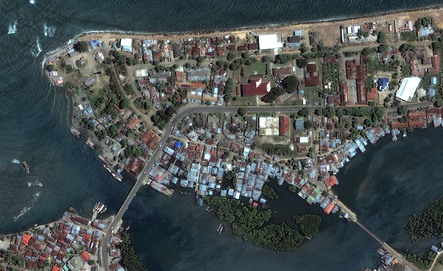
Figure 3.4: This is a satellite image on the city of Banda Aceh before the tsunami hit.
Source: http://www.peterloud.co.uk/indonesia/tsunami.html |
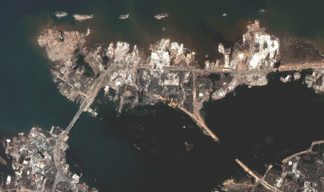
Figure 3.5: This is a satellite image of the city of Banda Aceh after the tsunami hit. As shown, many previous wharves and docks were completely covered and destroyed by the tsunami. In the the northern region in particular, the water is shown to have reached very deep inland, with lots of water even reaching the core of the city. Source: http://www.peterloud.co.uk/indonesia/tsunami.html |
Apart from the mass structural damage that occurred from the tsunami, there was also a large loss of lives as the tsunami extended so far inland that most people evacuating were caught in the disaster. A report from the Health Industry of Indonesia two weeks after the first tsunami hit indicated that 160,000 Indonesians were confirmed dead, with at least another 37,000 missing. The economic impact of this disaster however, was on another scale, with fifteen billion dollars being the immediate impact of the tsunami hitting Indonesia.
By examining this particular disaster, we can see the large extent that tsunamis from plate tectonics can have on Indonesia. Although such a large tsunami like this one is quite rare, Indonesia is continuously startled by offshore earthquakes that can potentially trigger a tsunami, with this particular case study important in showing the extent tsunamis can impact Indonesia. Despite the fact that the tsunami mainly only hit the Banda Aceh region in Indonesia, the high population density of the nation meant that a huge number of people (300,000) were still affected. However, the main impact of tsunamis in Indonesia is on the economy. With the high rate of relative poverty in Indonesia, the fact that tsunamis continue to destroy infrastructure and homes is meaning that there is no chance for the economy of Indonesia to improve and so, it can be determined that tsunamis are a major cause of economic failure in Indonesia.
By examining this particular disaster, we can see the large extent that tsunamis from plate tectonics can have on Indonesia. Although such a large tsunami like this one is quite rare, Indonesia is continuously startled by offshore earthquakes that can potentially trigger a tsunami, with this particular case study important in showing the extent tsunamis can impact Indonesia. Despite the fact that the tsunami mainly only hit the Banda Aceh region in Indonesia, the high population density of the nation meant that a huge number of people (300,000) were still affected. However, the main impact of tsunamis in Indonesia is on the economy. With the high rate of relative poverty in Indonesia, the fact that tsunamis continue to destroy infrastructure and homes is meaning that there is no chance for the economy of Indonesia to improve and so, it can be determined that tsunamis are a major cause of economic failure in Indonesia.
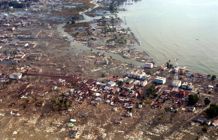
Figure 3.6: This is an aerial photo of the coast of Aceh, Indonesia after the 2004 tsunami. From the photograph, we can see that many houses have gone underwater, while the houses and buildings which remain above the water are surrounded by debris.
Source: http://www.australiangeographic.com.au/topics/science-environment/2012/04/why-was-there-was-no-tsunami-this-time/
Source: http://www.australiangeographic.com.au/topics/science-environment/2012/04/why-was-there-was-no-tsunami-this-time/
