Impacts of Volcanoes
The subduction of the Eurasian plate under the Australian has formed a region known as the Sunda Arc, which stretches for over 3000 kilometres from northern Sumatra to the Banda Sea, and is home to over 76% of the world's active volcanoes. The movement and convergence of these two major plate tectonics builds up pressure, often released through these active volcanoes. Since much of Indonesia lies in this volcanically active region, the nation leads the world in many statistics regarding volcanic eruptions. Indonesia has the largest number of presently active volcanoes with 76, and its total number of volcanic eruptions recorded of 1171 is only slightly exceeded by Japan. In addition to this Indonesia has suffered the highest number of volcanoes producing fatalities, damage to agricultural land as well as mudflows, domes and pyroclastic flows. Indonesia has some of the world's largest and most powerful volcanoes, and those that are large and steep can cause avalanches where debris drawn by the volcanic flows is transported to more populated areas, where the damage is multiplied.
The subduction of the Eurasian plate under the Australian has formed a region known as the Sunda Arc, which stretches for over 3000 kilometres from northern Sumatra to the Banda Sea, and is home to over 76% of the world's active volcanoes. The movement and convergence of these two major plate tectonics builds up pressure, often released through these active volcanoes. Since much of Indonesia lies in this volcanically active region, the nation leads the world in many statistics regarding volcanic eruptions. Indonesia has the largest number of presently active volcanoes with 76, and its total number of volcanic eruptions recorded of 1171 is only slightly exceeded by Japan. In addition to this Indonesia has suffered the highest number of volcanoes producing fatalities, damage to agricultural land as well as mudflows, domes and pyroclastic flows. Indonesia has some of the world's largest and most powerful volcanoes, and those that are large and steep can cause avalanches where debris drawn by the volcanic flows is transported to more populated areas, where the damage is multiplied.
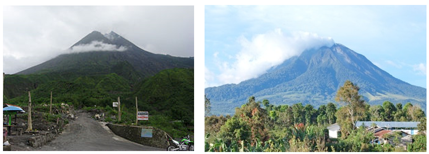
Figures 4.1 and 4.2: A photo of the Mt. Merapi volcano (left) and a photo of the Mt. Sinabung volcano (right). These are two of the most active volcanoes in Indonesia in the past decade.
Source (Mt. Merapi): https://theextinctionprotocol.wordpress.com/2012/05/01/indonesias-mount-merapi-volcano-entering-preparation-stage-before-an-eruption/
Source (Mt. Sinabung): http://www.livescience.com/41232-sinabung-new-eruption-pyroclastic-flow.html
Source (Mt. Merapi): https://theextinctionprotocol.wordpress.com/2012/05/01/indonesias-mount-merapi-volcano-entering-preparation-stage-before-an-eruption/
Source (Mt. Sinabung): http://www.livescience.com/41232-sinabung-new-eruption-pyroclastic-flow.html
On average, there is at least one significant volcanic eruption in Indonesia every year. Fortunately however, the damage caused to the environment, as well as the casualties that result from it are usually limited as most active volcanoes are located in isolated regions, since most people are understandably afraid to live in such a risky location. Nevertheless, the relatively high frequency of volcanic eruptions (see graph), likely due to the large amount of active volcanoes in Indonesia, is disrupting the everyday lives of many people in Indonesia, as evacuations are often seen as a necessary precaution even when there is minimal risk of an eruption actually reaching the Indonesians in the region located somewhat near the volcano. However, this is nevertheless required, as it is currently still impossible to halt the pyroclastic flows and mudflows that are produced by volcanic eruptions. Destruction of farmland, buildings and other infrastructure are therefore unavoidable from the effects of volcanoes.
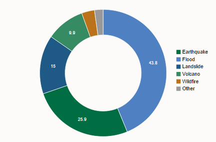
Figure 4.3: This is a pie chart showing the comparative frequency of different natural disasters in Indonesia. As shown, volcanic eruptions are the second most frequent, making up an average of 25.9% of natural disasters in Indonesia per year.
Source: http://www.preventionweb.net/countries/idn/data/
Source: http://www.preventionweb.net/countries/idn/data/
Case Study: Mt. Merapi Eruptions 2010
Mt Merapi is Indonesia's most active volcano out of the 76 active volcanoes it currently owns. The constant subduction of the Indo-Australian Plate under the Eurasian Plate has caused Mt. Merapi to regularly erupt since the 1500s, with one of the most major series of eruptions occurring in 2010. The volcano lies immediately north of the city of Yogyakarta, one of the most densely populated areas in the world, which means it regularly threatens the lives of the people in the city. The 2010 eruptions of Mount Merapi began in late October 2010 when the volcano began an increasingly violent series of over 20 eruptions that continued up until late November.
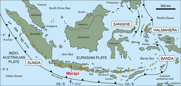
Figure 4.4: This is a diagram showing the location of Mt. Merapi, as well as all the other active volcanoes of Indonesia (indicated in yellow), in relation to the Sunda Trench, a geologically active zone, as well as the Indo-Australian Plate and the Eurasian Plate
Source: norfolkfireworkvolcano.com
Source: norfolkfireworkvolcano.com
Upon notification of the first incoming eruption of Mt. Merapi, over 350,000 people consisting of the dwellers living near the foot of the volcano, as well as a large portion of the people in Yogyakarta immediately evacuated. However, during the series of eruptions spanning over two months, many people tried to return to their homes in an attempt to save their belongings. As a result there were 138 deaths as well as 353 people injured, many as a result of the pyroclastic flows that continually extended its reach throught the city of Yogyakarta.
The long sequence of eruptions of Mt. Merapi in 2010 also released large amounts of sulfur dioxide, which found its way into the stratosphere (upper atmosphere). Sufficient quantities of sulfur dioxide in the atmosphere can irritate human skin, eyes and the upper respiratory tract, but more importantly, chemical reactions occurring in the stratosphere can result in reflective aerosols being created, which can linger for many years, and result in a considerably cooler climate by reflecting sunlight, which some animals in Indonesia may not adapt to. Furthermore, some of the sulfur dioxide reacted with water vapour in the atmosphere, which subsequently led to periods of acid rain in Indonesia in the months following the volcano's eruption.
The long sequence of eruptions of Mt. Merapi in 2010 also released large amounts of sulfur dioxide, which found its way into the stratosphere (upper atmosphere). Sufficient quantities of sulfur dioxide in the atmosphere can irritate human skin, eyes and the upper respiratory tract, but more importantly, chemical reactions occurring in the stratosphere can result in reflective aerosols being created, which can linger for many years, and result in a considerably cooler climate by reflecting sunlight, which some animals in Indonesia may not adapt to. Furthermore, some of the sulfur dioxide reacted with water vapour in the atmosphere, which subsequently led to periods of acid rain in Indonesia in the months following the volcano's eruption.
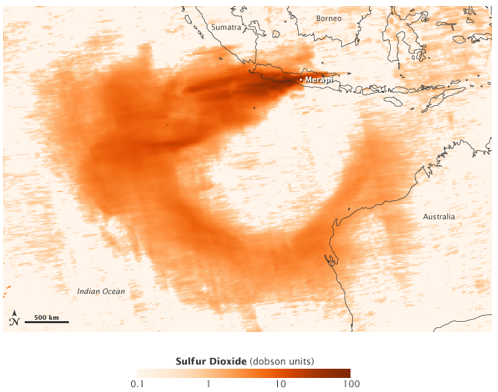
Figure 4.5: This is a chloropleth map showing the concentration of sulfur dioxide in the atmosphere near Mt. Merapi in November 4, 2010, during the eruption. The darker shades of orange indicate higher levels of concentration, with the darkest shade at Mt. Merapi being around 90 Dobson units in terms of concentration. The spread of the sulphur dioxide is in a horseshoe shape, with some of it even spreading to the border of Australia showing the extent of the sulphur dioxide released.
Source: http://earthobservatory.nasa.gov/NaturalHazards/view.php?id=46881
Source: http://earthobservatory.nasa.gov/NaturalHazards/view.php?id=46881
The eruptions and subsequent release of ash plumes and sulfur dioxide also caused extensive disruptions to the aviation industry in Indonesia. Flights across central and Western Java, as well as those from the Indonesian cities of Bandung, Jakarta and Solo and many international and domestic flights were suspended for almost all of November and December in 2010, due to limited visibility in the air. Yogyakarta's International Airport was entirely closed. As a result, tourism to the cities near Mt. Merapi plummeted throughout the following year, which meant income also vastly decreased, ultimately ending in economic turmoil for the local economy. Government officials reported that the overall economic loss resulting from the string of eruptions totalled over 5.5 trillion Rupiah ($600 million), due to the death of livestock and damage to the tourism, manufacturing and agricultural sectors.
This case study simply describes how a single volcano in Indonesia devastated the local economy there. It must be kept in mind that Indonesia has With today's technology, loss of life is no longer the main problem resulting from volcanoes.76 active volcanoes, a larger number than any other country in the world. Although a large scale eruption like the 2010 Mt. Merapi eruption occurs in Indonesia only once per 4 years on average, Indonesia is still plagued by constant eruptions of smaller scale, but extremely frequent volcanic eruptions.
Many of the 138 people who died from the Mt. Merapi eruption, were those who stayed, or returned to their homes in hope of saving their belongings. With today's technology, loss of life is no longer the main problem resulting from volcanoes. The economic impact resulting from these eruptions however remains. The Earth's plate tectonics will continue to move, and with it, natural disasters such as volcanic eruptions, floods and earthquakes will continue to occur in Indonesia meaning Indonesia continues to struggle today with the economic burden from natural disasters. Government and group intervention through responses aiming to help Indonesians better cope with natural disasters are required in order to relieve Indonesia of its economic and social troubles.
